One Airport Named for Two Aviators

Aviation’s role in San Diego history can be summed up in the lives—and names– of two men. One was John Montgomery. In the late 19th and early 20th century, Montgomery was a physics professor at Santa Clara University in northern California, but he was also a researcher, experimentor and inventor in the then-new field of aviation, which at that point in time was still confined largely to hot-air balloons. The photo below, courtesy of Wikimedia Commons, shows Montgomery in 1905 standing beside one of the gliders he built to engage in experimental, and brief, flights :

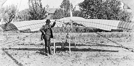
Some years earlier, in 1883, Montgomery took a similar device to a ridge at Otay Mesa, where his family owned some ranch property. There he leaped off the ridge and glided roughly 600 feet before landing, completing what’s considered one of the earliest controlled-wing flights in history.

San Diego’s sunny climate would be a boon to the development of aviation, both civil and military. World War I and its aftermath would see the establishment of Army and Navy air stations as well as aircraft manufacturing companies like Ryan and, in the mid-1930s, Consolidated.

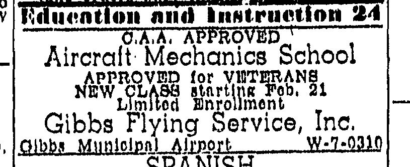
Lindbergh Field would be opened in 1928 as the city of San Diego’s first municipal airport, but the ensuing decades would see smaller, privately-owned airfields pop up, often by private pilots offering air excursions as well as flight and mechanic schools and other flight-related services. One example of that was Bill Gibbs, a young pilot who took tourists on aerial tours and used the proceeds to buy his own plane. He did well enough offering excursion flights, as well as flying lessons, to take out a bank loan in 1937 that he used to buy land on Kearney Mesa where he built an airfield. Gibbs Field became the base for Gibbs Flying Service.

Below is a typical ad seen in San Diego newspapers from the 1930s through the late 1940s:

The City of San Diego purchased Gibbs Field from Bill Gibbs in 1947. In May of 1950 the city officially changed the name of Gibbs Field to Montgomery Field to honor John Montgomery’s pioneering flight on San Diego territory.

In a sense the city came full circle in 2016, when the airport’s name was changed again to Montgomery-Gibbs Executive Airport, the name it carries to this day.

A Local Lake Then and Now

Below is a photo taken in 1887 for the book, Picturesque San Diego, showing Lindo Lake in the then-new community of Lakeside:

Below is a photo taken earlier this year by your History Seeker team, on a visit to the still-existing and still beautiful body of water, now part of Lindo Lake County Park:

Worth a visit, friends, to sample San Diego County’s historical and natural heritage.

How Water Changed San Diego

Access to a steady water supply made all the difference in making San Diego County livable. Vincent Nicholas Rossi, the San Diego History Seeker, will show how it happened in his new Oasis class, “How Water Changed San Diego.” Join him Friday, August 23rd at 1 p.m. ­­at Oasis Grossmont Lifelong Learning Center or on Tuesday, August 27th at 10 a.m. at Oasis’ Rancho Bernardo campus. Click on the link below to sign up:

https://san-diego.oasiseverywhere.org/?_presentershortname=Rossi,%20Vincent

Link To A Name From Our History

Ed Fletcher was a major mover and shaker in San Diego city and county history, remembered today by Fletcher Hills and Fletcher Parkway. The photo below shows Fletcher standing in front of the open spillway at the Lake Hodges Dam during a release of water from the dam’s reservoir in the early 1920s, shortly after the dam’s completion:

Fletcher was then the president of the San Dieguito Mutual Water Company, which built the dam. That company was one of a number of ventures which he led during his life to promote water development in San Diego County, efforts which played a big role in making San Diego County livable.

The photo is part of an archive of Fletcher’s private papers now held in the UCSD Library. The majority of those papers have been digitized, and so are available for public viewing. It’s a great source for history seekers. See the link below to check it out.

https://library.ucsd.edu/dc/collection/bb55647135

A Walk Through History, Natural and Human

On a recent Sunday morning, in need of some time away from work and home, my wife and I decided to talk a short walk on a nearby trail. Just a short drive from our neighborhood is the Mule Hill Historic Trail, adjacent to the Sikes Adobe Historic Farmstead. The trail and the farmstead are part of the San Dieguito River Park, which was created in 1989 to preserve a chunk of the San Dieguito River watershed, from Volcan Mountain near Julian to Del Mar on the coast, as undeveloped greenspace.

The Mule Hill Historic Trail offered us some great examples of history, both natural and human.

Here’s an example of the natural part:

The bolders and flowering vegetation offer a glimpse of what all of San Diego County looked like for thousands of years.

And within a mile or so on the same trail is the scene of some significant human history:

The stone wall and historical markers look out on Mule Hill, site of the climactic final stage of the Battle of San Pasqual in 1846, during the Mexican-American War. The US victory in that war in 1848 would transform California from a Mexican province to an American state.

A lot of history in a short hike. Check it out!